FLOATING EMERGENCY SHELTER : FINAL SUMMARY OF CONCEPT
ONCE LOCALS ARE INFORMED OF A POSSIBLE NATURAL DISASTER, THOSE WHO ARE ABLE TO, WILL EVACUATE THE TOWN. THE MOST VULNERABLE, (ELDERLY, FAMILIES WITH CHILDREN, PEOPLE IN POVERTY ETC) HAVE THE OPPORTUNITY TO GATHER AND STAY AT THE EMERGENCY SHELTER FOR THE IMMEDIATE IMPACT AND AFTERMATH OF THE DISASTER. THIS WILL BE UNTIL STRONGER GOVERNMENTAL PROCEEDURES (IE. RE-HOUSING VICTIMS) ARE IMPLEMENTED.
THE DESIGN AIMS TO MINIMISE NUMBER OF DEATHS, EASE THE MENTAL TOLL ON VICTIMS, PROVIDING LOCALS WITH SERVICES TO HELP THEM GET BACK ON THEIR FEET (LONG TERM). STAFF/VOLUNTEERS OPERATE THE SITE WITH THE ASSISTANCE OF SECURITY FORCES.
THE SHELTERS ARE ADAPTED IN SLIGHTLY DIFFERENT WAYS TO SUIT THE TOWN’S INDIVIDUAL NEEDS (ie. REINFORCING THE NEW ORLEANS LEVEES AND PERMACULTURE PRACTICE IN MYANMAR - RELIES HEAVILY ON THE AGRICULTURAL INDUSTRY). THIS ADDED PERSONALISATION SUGGESTS THE SUSTAINABILITY OF THE DESIGN AND HOW IT CAN SPECIFICALLY BENEFIT THE AREA INVOLVED BEFORE AND AFTER THE DISASTER. THESE COULD BE ONE OF MANY SHELTERS AROUND THE WORLD, TARGETTING OTHER COASTAL AREAS SUSCEPTIBLE TO HURRICANES/FLOODING.
PROVIDING PROTECTION FROM NATURAL DISASTERS AS WELL AS THE MAN-MADE, SOCIAL ISSUES WHICH CAN FOLLOW.
Evaluation Presentation
Reflection: Evaluation Week
30/04/20
I have now finished my evaluation video and have uploaded the final above. This was a very useful project, which allowed me to fully reflect on my entire experience of the final project. I now aim to complete any final touches to my workflow pages, adding sketchbook photos etc. The foundation year (despite Covid-19) has been a truly wonderful opportunity which I am so glad I participated in. I have learned a heck of a lot over the last months and can see a massive improvement from my part 2 and part 3/unit 4 works compared to part 1. I feel I have become more confident in my designs, presenting my work and answering questions about my work. Experience in the workshop will definitely be a plus when. it comes to workshop practice next year at CSM. Thank you tutors :)
Reflection: Evaluation week
28/04/20
Today, I have been editing my presentation on powerpoint and recording the VoiceOver over the top. I then dragged both audio and presentation into Adobe Premiere to edit them both together. At first I had an edit of 5:50, therefore, I have tried to cut down the video as much as possible. I kept tweaking the video, listening out for any repeats or unnecessaries which I could delete to grab just the essential information.
Reflection: Evaluation week
27/04/20
Today, I began planning for my evaluation project. I was originally going to write the essay, but thought making a video would be a nice opportunity for this activity. Below is my plan for the evaluation, I decided to split the categories I wanted to talk about using www: what went well and ebi: even better if to analyse my own work. I also aim to use the provided questions on the evaluation document.
Reflection:
23/04/20
Today, I continued sketching my site designs, using a range of free-hand and perspective drawings. I am also keeping up to date with my checklist as seen below:
Reflection: Portfolio Sheets
21/04/20
As I am approaching the end of the project, I have made some digital portfolio sheets for my project (Featured on Sketchbook and sheets page). I think viewing these sheets as a whole, really brings the project together- answering the 5 w's on my design. I thought it was necessary to show these pieces of work, hopefully presenting a clear and direct overview of my project and its purpose. Seeing as we are not presenting the contact sheets to the class, I have included a fair amount of text on my sheets (which I wouldn't usually do, as well as, the large amount of sheets). I have really enjoyed this project, despite being in lockdown. It has definitely given me the opportunity and motivation to keep creating, keep updating my project - working towards a final deadline. I think, if I hadn't joined the foundation course, I would've been very bored and unmotivated at home, but this gave me something to put all of my effort and ambition into. It has taught me a lot about preparation and time management (especially in such circumstances where we are working independently without being in a class setting- it is up to you whether you continue your work and it is easy to become behind on work).
Reflection: Model Making
20/04/20
Today, I made a model of one of the cabins on the site. I decided to make a 1:700 scale model of the Living Quarter(s) - which have the same dimensions in each site. I found making the octagonal prism quite a challenge at first as I couldn't afford to make the slightest incorrect calculation/measurement otherwise the model would not achieve its perfect octagonal shape. It required a lot of YouTube researching geometry, compass and angle work- although, I wanted to challenge myself to make my model as accurate as possible. A lot of it I remembered from Maths GCSE, so in some respect, it was quite interesting to revisit. I made my model using cardboard and paper, as well as twigs to replicate the oak/log layering construction. The plastic airbags which lay under the structure represent the Megafloat (Very Large Floating Structure) which allows the entire complex to float.
Please see digital outcomes for water demonstration video
Reflection: Visualising Interior of Living Quarters
Please see digital outcomes
As both Living Quarters (dormitories, common rooms, communal kitchens etc) in both sites have the exact same dimensions, I thought it would be an interesting area to put more focus on. I used Sketchup to create the living quarters in a 1:1 scale. This really tested my sketchup abilities as I had never drawn to scale digitally before. Nevertheless, using the actual measurements, I created my structure, producing axonometric diagrams also.
I then progressed into designing the interior of a dorm room inside of the living quarter as seen below:
Family dorm room in the Living Quarter(s) - both sites
Reflection: Digital Representations (both sites)
16/04/20
Please see digital outcomes
Over the last couple of days, I have also been practicing my Sketchup skills and thought I'd make a digital representation of my Emergency Shelter. It was a challenge to create the roof structure, though, following YouTube tutorials, I finally worked my way around how to create it. I had never made a roof on Sketchup before, let alone an octagonal, rounded shape. I am very pleased with the outcome and photographed it from different angles to get a full sense of the property. After completing my sketchup model, I brought the images into photoshop to add some textures. As per my materials, I used the clay tiles for the roof and created an oak log style framing. I did not focus on the technicalities of the structure, (ie. the floating device which sits below, or dimensions) as this was purely to display the basic idea, its function (floodwater background), and its cabin-like design. I created the floodwater by using the liquify tool to push/pull gradients in the water. I honestly love practicing my craft digitally, it allows me to edit and rearrange even when I have finished the outcome. I can also experiment with different styles of visual which I am unable to do multiple times with a physical model. Nevertheless, I aim to create a physical model over the next few days.
Below is a final rendering of the Emergency Shelter at the Labutta, Myanmar site:
Below is a final rendering of the Emergency Shelter at the West Lake Forest, New Orleans site:
Reflection: Choice of Design
I chose to design my floating emergency shelter in a particular way to make locals feel welcome or almost, "at home", which obviously would be very difficult during such disastrous times (flood/hurricane). Nevertheless, the design does its best to create a homely, warm environment which is suggested by the strong and stable, rich, oak beams, perhaps reminiscent of a home environment. The designs encourage social activity in its garden, education and dormitory areas, spaces for community to interact and comfort those who may be stressed at the time. The medical centre- meditation, counselling areas allow people the choice to speak to a healthcare professional, assisting them with any mental or physical related issues. Both sites are designed with pathways which connect the cabins- with emergency pontoons to ensure the safety of the guests. The octagonal shape of the individual cabins (explained previously), is built in this particular shape to enhance the strength of the structure (necessary during extreme weather conditions). Due to the immense scale of the design (s), it can provide comfort to the guests, almost providing them with a guarantee of safety during their stay.
Reflection: Materials and Technical drawings
14/04/20
14/04/20
I thought I would create a visual representation of the materials for the project. I like to draw using perspectives so this was a rewarding activity for me. I thought it would be more interesting to draw the materials as opposed to just printing images or writing a list. The materials used are also featured on my research page but the list includes: Structural Oak logs/beams, steel, glass, clay roof tiles and the mega float. I will continue representing these technicalities by drawing sections and elevations of my design.
Planning:
Reflection: Sketches of Design
13/04/20
I have recently drawn a double page spread of my Floating Emergency Shelter (West Lake Forest, New Orleans site). I used a one point perspective and showed an overview of the entire complex. I have made a plan of set sketches to complete over the next couple of days including diagrams as well as, more relaxed, quick sketches which I was told to work on during part 1 + 2. I have found its very easy to forget to take breaks from work, I allocated days where I would work and others to relax. It's important to find a balance of both, nevertheless, I wanted to create a large body of work for my final project as this issue of climate change, rising sea levels, human adaptation, is something I am deeply interested in and have really enjoyed working on.
Reflection: How will my structure float?
09/04/20
Whilst sketching my design ideas, the thought of how exactly my structure would float did come to me as quite an issue. After viewing the well-known 'Makoko Floating School' which floats on recycled plastic barrels, I realised this method would not suffice the immense and somewhat complicated structure of my design. I then began researching how larger structures such as ships have the ability to float on water and came across ferrocement (a composite material composed of a mortar reinforced with light steel fabric/mesh which allows it to float). I felt a little overwhelmed researching into all these different materials I had never heard of, nevertheless, I thought it was essential if I felt my design could actually be implemented in the real world. A couple of days later, after researching into VLFS (very large floating structures), I came across a new technology called 'Megafloat' - as referenced on my research page. It allows heavy weighted structures to float on water. This was a much simpler method which I believe is perfect for the large scale complex. It took a lot of research and going down different paths though, it was worth it in the end. This has now given me the knowledge on how to begin my technical sheet- dissecting each section of my design piece by piece. I aim to complete technical pages over the next week or so.
Reflection: Masterplans
07/04/20
After completing the masterplan for my Labutta, Myanmar site, I thought I would create an abstract site map for the West Lake Forest, New Orleans site. This was not to scale but I felt it conveyed the same message in a more creative and visually interesting fashion. Exploring different ways of representing a masterplan was quite fun, I prefer my abstract plan as It is more striking. Nevertheless, I am proud of the level of detail put into the Labutta masterplan and this style is more similar to the types of plan I assume I will be creating in my BA course (so this is good practice).
Reflection: Masterplans
06/04/20
Today I started drawing the masterplan for my Myanmar site. With the real scale dimensions next to the plan, I created the map at a 1:2000 scale due to how large the actual building would be. I am quite enjoying this task, although, it can become a little tedious, I wanted to draw my plan as opposed to creating it digitally as I know I will be producing a lot of digital content over the next few weeks and thought it would be a nice change compared to my previous projects.
Reflection: Planning the Areas Featured in Both Emergency Shelters
02/04/20
I have been planning the interiors of my emergency shelter and work out where each area would go throughout my two sites. The list below depict the categories I aim to split each area into. The following will apply to both sites as I feel they are crucial for human progression and helping users get back on their feet after such a trauma. I will continue to represent the various sections through a masterplan and a series of interior sketches:
Reflection: How the Site Designs Vary
31/03/20
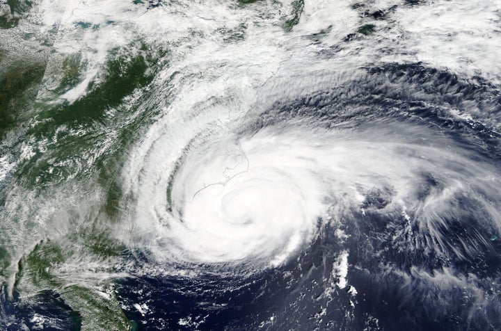
Throughout my project, I have focused a large amount on the secondary impacts of disasters and social issues which can form/worsen during the aftermath. Each site, (Labutta, Myanmar and West Lake Forest, New Orleans) had different circumstances during Cyclone Nargis and Hurricane Katrina.
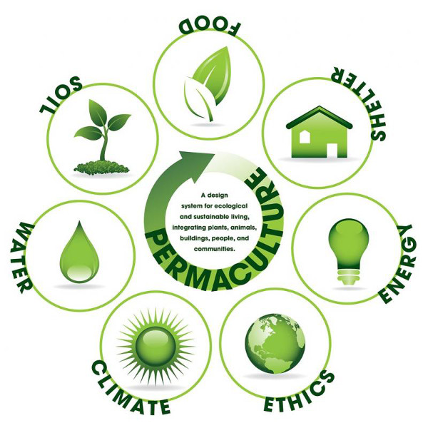
I chose to address the social issues and secondary impacts of natural disasters in Labutta by incorporating permaculture into its design. Practising permaculture would come as a great advantage for Labutta, allowing the community to work with its environment, learning how eco-systems can feed into each other etc. One of Myanmar's main industries is agriculture. Educating locals on permaculture would reduce the deforestation levels in Myanmar, and instead encourage growth and how to sustainably maintain land, crops, cattle etc. Not only could it benefit the community in Labutta, but the entire country. I did not include as much permaculture related design in the West Lake Forest, New Orleans site as Labutta is very rural compared to the urbanised New Orleans' area (less agricultural land/less farming practises). Their industries are more likely to focus on secondary, tertiary industry sectors as opposed to primary. It may not have had as great of a benefit.
I chose to address the social issue of gun crime through my West Lake Forest, New Orleans site by including bulletproof glass as a main material around the site. As well as, the issue revolving around the faulty levees which were built to help ease the effects of Hurricane Katrina and failed to do so. As we all know, America's disastrous gun issue has cost thousands of innocent lives. Specifically, the cases of gun crime reported increased after Hurricane Katrina and was a major cause for concern at the Louisiana Superdome (where thousands of people were left unprotected in "unsafe" conditions, seeking refuge in the centre). I aim to provide a safe zone for thousands of people who are already under stress due to a natural disaster. Both sites will obviously have a gun disposal/no gun policy but this is more specific to the New Orleans site (as they have more of an issue. As shown in the Michigan High School Proposal, curved corridors may also serve as a benefit to protecting intrusions (blocking the view of any perpetrator). The design's circular form will incorporate this security method. I have also include the failure of the New Orleans Levees, which had a major impact on the amount of flooding. If they had worked correctly, there would have been less of an impact. There will be a sediment collection facility area in my New Orleans site. Sediment will be collected from the floor of the lake, packed by people on site and transported by boat to help reenforce the levees. It might be seen as a rewarding activity as users will feel they are contributing to the redevelopment of their area.
Reflection: Sketch Models
I created another set of sketch models, focusing on roof design for the octagonal base. This came as a little bit of a challenge as I was then lead to work out how to create a roundhouse roof, understanding the framing behind it- which i will need to build my model. I experimented with several conical roof shapes using sticks, lollipop sticks and card. I felt I created some interesting formations which will help me to sketch technical presentations of my design.
To-do list 1/2 completed
Reflection: FINAL CONCEPT
30/03/20
After sketching and considering various designs, I have slightly veered away from designing a multi-functional school (which can be used as an emergency shelter in times of disaster) and more-so the other way around- creating an emergency shelter which harbours essential facilities needed for society to progress and recover easier from a natural disaster. The essential services include: basic shelter (beds), help services, a few classrooms - for children to continue learning etc. The building aims to protect users from natural disasters as well as, to help protect/alleviate man-made/social problems which worsen after such an event. An emergency shelter which goes just a step further than a traditional centre- particularly convenient at times of an unstable, unreliable government ie. case studies. I found the sketching a convenient and effective way of displaying my design ideas. Over the next few days, I aim to sketch larger, two page spread drawings of my emergency shelter using 3 point perspectives, plans and orthographic projections.
Despite differences in areas of land, I aim to use the same cyclic structure, allowing any waves to be deflected around the property.
West Lake Forest, New Orleans
Labutta, Myanmar
Reflection: How I Can Address the Secondary Impacts and Social Issues Worsened by Disasters
26/03/20
On my research page, I assessed the various secondary impacts and responses which occurred for each disaster- Cyclone Nargis: Myanmar and Hurricane Katrina: New Orleans, Louisiana. This allowed me to understand what services I could provide through design in order to help alleviate social issues which can arise or worsen during the aftermath of natural disasters. I noticed that in some cases, there was a difference between priorities for LEDCs vs MEDCs. Myanmar was most concerned with agricultural issues- as their economy mostly revolves around the primary industry sectors. I found that a major concern for Louisiana was the issues which came with the Louisiana Superdome (which become an issue with lots of media coverage). As well as this, they have many political issues involving government - which is not always within our control and therefore, is more difficult to address through the design. Both governments were criticised for an initial lack of adequate response but overall, Myanmar's government had a truly awful response. Social problems arose in both sites, gun crime particularly in U.S and a large increase in human trafficking, abuse in Myanmar (which already has a major issue). I would like to address some of these issues and ways of alleviating some of these problems and creating a safe space for these difficult periods, through design. I wanted to make sure I didn't rush straight into the design process as I wanted to think about how I could reference these issues properly. It took a lot of research, though, I am glad I did this as I needed evidence and knowledge on these issues. I brainstormed some ideas below:
Social issues which could be alleviated within my design:
In both cases, crime rates among communities increased during the aftermath of the disaster.
Mental health/spaces/zones-
Family zone (particularly for people with children/safety reasons)- nursery area?
Help, education centres and counselling- abuse, sexual exploitation, - women in particular, financial assistance
Bulletproof materials - to prevent damage of any gun related crime- specifically for U.S site
Food, water, medical delivery port/entrance for deliveries.
Special entrance for medics, supervisors etc.
Not a hospital, but a shelter- hospital separate. Shelter is not for ill patients.
Farming facilities - perm culture- for Myanmar site.
Reflection: Site mapping
24/03/20
Over the past couple of days, I have been editing maps on Photoshop, displaying my two sites my design will operate in: West Lake Forest, New Orleans and Labutta, Myanmar. I find my site analysis to be quite successful as I wanted to share as much information about the site in as few maps as possible. I particularly enjoyed making the flood maps, I felt these were essential for understanding the amount of devastation these hurricanes (case studies) had previously caused. This highlights the most vulnerable areas susceptible to major flooding to my audience, showing where needs to be helped the most. I feel all of my previous design has had a social impact, I enjoy creating proposals which will directly benefit the users involved. Basic things such as shelter and protection from weather is something I, myself can take for granted. It's important that we help create solutions to these now frequently occurring disasters and lessen the severity through sustainable living ideas/aid.
Reflection: Site mapping
23/03/20
Myanmar maps to edit:
1. map ilustrating nearby hospitals, aid check points in comparison to Labutta (maybe- not entirely necessary)
2. Map of specific land space in Labutta DONE
3. Overall global map showing where Myanmar is- Perhaps a photo overview of just Myanmar within the same global map. DONE
4. Flood map. DONE
5. Possible Routes which can be taken to get to the site (combine with no 1)
New Orleans, Louisiana maps to edit:
1. Map of Louisiana within overall map of U.S DONE
2. Map of specific area in West Lake Forest, New Orleans DONE
3. Flood map DONE
Project development questions week 27
1. Hiya, even though my primary research is based in Florida (ie. Interview with my Aunt and video) is it okay to use New Orleans as my site? They are closely linked (New Orleans was worse affected by Hurricane Katrina) so I thought it would be fine. But just wanted to check. I was worried it would be a bit confusing as I'd have primary research in Florida but building in New Orleans, Louisiana. I would prefer build in New Orleans because I really like the architecture (Spanish, French influences) and its overall history- theres so much to say /about it.
2. Any other research angles I could look into?
see sketchbook on other slide
Thanks : )
Project Overview week 27
Project Concept- Designing a multi-functional (most likely) school which doubles up as an emergency mass shelter in times of hurricanes/tsunamis. (The school uses protective architecture such as flood defences, stilts, floats etc). Visualisations and analysis of how the design would operate in an MEDC vs LEDC (more economically developed country vs less). The design will alter slightly depending on area as they suffer from different demands/secondary impacts during natural disasters.
Site- MEDC (New Orleans, Louisiana- using Hurricane Katrina as case study) and LEDC (Myanmar, Cyclone Nargis)
Form- Undecided. Organic? Dome/shell kind of shape?
Structure- steel framing? dome? barrel roof? Curved roof? Circular structure to deflect the brute force of the wave (water goes around property instead). lattice structure? - very strong
Material- Timber, concrete, steel, stone - strong materials. Experimental materials- Mycelium composite- mushroom
Cementitious waterproofing,
Scale- Large in reality, 1:100/1:60 model?
User- Locals in need of emergency shelter and support during natural disaster, families, elderly, all age groups- needs to be wheelchair accessible.
Reflection: Reconsidering Sites
19/03/20
Louisiana site: West Lake Forest, Eastern New Orleans, Louisiana.
Myanmar site: Labutta
After completing the Myanmar, Cyclone Nargis case study, the next step I felt was a more in depth site analysis, exemplifying where exactly I would place my structure. Originally, I began my site analysis in a tourist region of Myanmar. I realised I didn't want my design to go directly in an area with lots of tourist attraction, I want it to be something that benefits the locals living in the least wealthy, flood prone areas in particular. Therefore, I went back and edited my research. This can be seen on my Research page. Re-doing the research was quite annoying, though, I felt this was necessary as I wanted my research to be as accurate as possible and my design to be as convenient for its users as possible.
I used the site survey sheet from a part 2 workshop to assess my sites. I felt this was a successful way of evaluating all aspects of the area of Labutta or Laputta, situated on the Irrawaddy Delta.
Problems:
1. Problems with building in a disaster prone area- controversial - my view for this circumstance- yes, we can build as there are still thousands of homes which stand in this area. We cannot afford to leave the most vulnerable to fend for themselves during these times. If it was a housing complex being built, I would’ve said no- ultimately, due to increasing natural disasters and coastal erosion, locals will need to be relocated further and further back from the shore, rebuilding on these surfaces will soon become pointless. However, seeing as this is an emergency shelter, it should be treated differently- it is for pre existing households within the area who maybe cannot afford to move out.
2. I began looking for areas I could build on within Labutta and realised a lot of it is agricultural land, which personally, I would not want to build on and destroy. Deforestation is already a severe problem in Myanmar, I would also not consider cutting down trees to create space. Therefore, careful and sensitive placement is necessary.
"1) A healthy ecosystem is maintained and enhanced, to protect and provide for people; 2) A diversified, inclusive and resilient economy, to enhance the economic conditions of the township; 3) A resilient infrastructure and connectivity, that protects people and enables. In this scenario, efforts are sustained in an inclusive manner over a long period of time, and by a number of actors, but particularly the local and national government."
- from The Global Climate Change Alliance Plus Initiative Assessment of Labutta Township
Reflection: Case Studies
17/03/20
Due to the whole Coronavirus situation, I couldn't print as much content for my sketchbook as I usually would've done. I had to come up with alternate, more creative ways of presenting my ideas. For my Hurricane Katrina and Cyclone Nargis case studies in my sketchbook, I instead decided to do some paintings to convey 'life after the storm'. This can be seen in my pdf above. In the end, I believe not printing out all of the photographs came as an advantage. I was very pleased with the outcomes. I now prefer my paintings and might continue using this form of media throughout the rest of the project. I realise its about working around the situation, which can produce some very interesting outcomes compared to just cutting and sticking an image.
Reflection: Last Day- A Change In Plans
16/03/20
After the change in events, I decided to plan out my weeks to keep me on track in able to finish the project. I created a list of pages I aim to complete over the next couple of weeks, which I will continue to update as time goes on. I felt this was extremely important as I felt I could easily stay at home and forget to work. This planning allows me to stay on top of everything. At this moment in time, I had to think ahead, I did a lot of printing for my sketchbook- as I knew I wouldn't be back for a while. Below is my list:
Throughout the day, I quickly went to the wood and plastic workshops to create some sketch models. I mainly focused on building rounded surfaces and curved structures (to deflect the force of the wave). I used the bandsaw to create the curved edges, sanding it down on the disc sander and used the oven to heat and create interesting free-flowing forms- potentially for the roof. These can be seen below:
Reflection: First Stages of Idea Development
05/03/20
First stages of Ideas Development and Sketch Model Making
Reflection: Sites to Visit
Do all in one day - postponed due to Coronavirus stuff :(
Home- Roca- Design Museum- Natural History- home
Sea Change: Flood Resistant Architecture at Roca London Gallery- http://www.rocalondongallery.com/expositions/sea-change-flood-resilient-architecture-for-the-21st-century
Design Museum- Bio Logics: Designing with Nature - https://designmuseum.org/exhibitions/bio-logics-designing-with-nature
Volcanoes and Earthquakes Exhibition at Natural History Museum- https://www.nhm.ac.uk/visit/galleries-and-museum-map.html
Polly Gould- Architecture for an Extinct Planet- Kennington- https://www.artrabbit.com/events/polly-gould-architecture-for-an-extinct-planet closed on mon tues and weds
Thames Barrier- from the Thames Barrier Park
Embankments- Victoria Embankment- opposite/viewable from Southbank
Reflection: Establishing final idea
04/03/20
Confirming my design idea
After a feedback session with one of my tutors, I decided on creating a school, strong enough to withstand a or a number of natural disasters. I would like to incorporate some safety against or reference to man-made disasters also in some way as both are mentioned in my project title. I believe creating a school is the one of the most effective buildings to design in terms of child development, serving as a crucial foundation stage for the rest of a child's life. They can also serve as shelters at times of disaster- as seen during Hurricane Katrina (2005) when locals gathered at the sports hall. They are there to guide children into the next stage of their life. I gather there is a huge responsibility when it comes to designing a school, the safety of the pupils and staff, operating facilities, ensuring the space can withhold the capacity of student. I am excited to construct this as I can dip into interior architecture, arrangement and mapping of the school as well as the exterior.
One way of adapting the USP of my school was by incorporating perma-culture- designing a sustainable school that fends for and operates itself- self regulating. I.e pupils taught to grow their own crops which they then can sell/eat. This would be most effective in less wealthy or LEDC's (Less Economically Developed Countries)- which is another point to think about.
I think this is a great starting point for my project. I aim to research perma-culture in much more depth and understand ways of incorporating it into my own design. I aim to look into the designers of and layouts of schools - using sites that I operate in for primary research for starters (CSM Archway and King's Cross). Next stage idea development/ site analysis - I aim to create site mapping through digital and physical collages and drawing representations. COULD CREATE OWN PIE CHARTS AND GRAPHS FOR RESEARCH. Poll?
Reflection: Primary Research
Part of the feedback for my part 3 assessment suggested I explore different forms of primary research. I thought it would be quite exciting to take this on and enhance my recording skills. Therefore, I decided to interview my aunty who lives in Florida about what she remembers of Hurricane Katrina. I also created a video to further explore the state's low level terrain and the affects these tropical storms can have on a community. Below is the plan of primary research which I have completed and will continue to update.
Reflection: Ways of including "Man-made" faults/causes
Looting occurs in event of natural disaster- increased crime rate.
Could build school (perma-culture incorporated), which in case of a natural disaster it serves as a shelter also? - protecting people from the natural disaster and its secondary effects- shooting, looting/stealing anti social behaviour) - bullet resistant or security architecture. - This is more likely to occur in less wealthy areas in MEDCS (such as New Orleans) So, could base design in this site.
Or visualisations of the school in various countries which are disaster prone sites and how the exact same school design would be adapted slightly to suit countries needs and priorities. - Ie. Myanmar (hurricane disaster) - people assumingly, would've had slightly different priorities to New Orleans. U.S has more resources - more sufficient and fast producing aid available than other countries. ADAPTABLE DESIGN?
Compare disaster aid after hurricanes between the two countries.
Primary/secondary impacts etc.
Reflection: Why I Chose Disaster-Prevention?
03/03/20
The impact of climate change is diverting the conversation, drawing more attention to flood prevention and defence from natural disasters, specifically in disaster prone areas. Such conversations are imperative to keeping our society safe within these times of tragedy, destroying homes, entire towns, even claiming lives. Changing the way in which we build and prioritising the most important issues will help to keep our towns safe. Nature has been manipulated over time, almost appearing as the enemy, wreaking havoc on the most vulnerable. According to OurWorldInData.org, natural disasters kill on average, 60,000 people per year, globally. Although, this is still an awful amount of people, the patterns over the last 100 years show a significant decrease in fatalities from natural disasters. This is mainly due to the increased awareness and preparedness of our society- i.e effective relief plans, aid, increase in advanced disaster warning systems and of course, the increase of defences and disaster proofing buildings. Despite the decrease in fatalities, the disasters have become more frequent as described in Figs 1 & 2.
I feel most empathy towards the statistics displayed in Fig 3, exemplifying the increasing number of people who have had to relocate due to the destruction of their original homes. This was the case for thousands of people affected by Hurricane Katrina (2005). I aim to create a design which aims to alleviate the drastic impacts of flooding by providing a solution(s) for people in disaster-prone areas. Although, I have never been directly affected by a natural disaster, I can understand how devastating it must be at first-hand experience (the physical and psychological damage), therefore, I am passionate about designing with this being the driving force of the project. No one should ever have to feel unsafe or unprotected in their home, our infrastructure should be built with the ability to withstand or adapt to the impacts of our changing climate.
"The high death tolls from natural disasters tend to be centred in low-to-middle income countries without the infrastructure to protect and respond to events." - OurWorldInData.org
Fig 1 - The graph displays the increasing frequency of natural disasters throughout the world from the 1952-2009
Fig 2- Graph depicting the increase of natural disasters from 1980-2016
Fig 3-
Fig 1 source: standeyo.com. (n.d.). Millennium Ark: Hot News. [online] Available at: https://standeyo.com/NEWS/10_Earth_Changes/100305.nat.diz.increasing.warning.html [Accessed 10 Mar. 2020].
Fig 2 source: The Economist. (2017). Weather-related disasters are increasing. [online] Available at: https://www.economist.com/graphic-detail/2017/08/29/weather-related-disasters-are-increasing.
Fig 3 source: Oxfam (2019). Graph showing climate disaster impact. [online] ABC News. Available at: https://www.abc.net.au/news/2019-12-03/graph-showing-climate-disaster-impact-1/11760548 [Accessed 11 Mar. 2020].
Shortened version can also be found on my research page
Reflection
02/03/20
Today, I chose to continue more in depth research. I just couldn't find an angle or lead to begin researching into more specifically. I wanted to make sure I had enough knowledge on natural disaster statistics, primary and secondary impacts, how architects have already been disaster proofing buildings etc. After some thought, I began to focus on flooding and the affect of hurricanes on communities, researching into case studies, i.e Hurricane Katrina as a main lead. I used the library at CSM to find a photography book on the lives of the community. I feel that taking time on my research is essential for a geographic topic like this, I wanted to base my design off of pre-existing evidence where a similar project has been successful.
Reflection: Man-made Disasters
27/02/20
I have recently been ordering books from other U.A.L sites, I was unaware of the breadth of topics covered across the colleges. I felt I should take advantage of these various research points and had several books delivered to CSM. One book I used for my research was called "Terror and Wonder" (I go into more detail on my research page). Although, very sensitive, the book assesses man-made disasters such as terror attacks. The fairly recent terror attacks in the U.K have sparked my interest in the need to protect our society from such atrocities, through the form of architecture. Of course, the situation can only really be controlled by addressing the root cause and reasoning behind these disasters, which is something much deeper and difficult to pinpoint. Nevertheless, anti-terror architecture has the ability to help ensure a community, allowing them to feel a little safer throughout these times. Less of a submission to the terror, but more as a warning, it holds power, taking back control of area (especially when the anti-terror architecture is disguised).
Fig 1

Fig 2- A graph comparing the cost of both man-made and natural disasters between 1970 and 2012
Fig 1 source: The Economist. (n.d.). The plague of global terrorism. [online] Available at: https://www.economist.com/graphic-detail/2015/11/18/the-plague-of-global-terrorism [Accessed 11 Mar. 2020].
Reflection: Venn diagram
26/02/20
A Venn diagram which was helpful in putting things into perspective in terms of things I value most within my discipline. I feel this is expressed through my work and believe that over time my disciplines will inevitably change with experience and knowledge. I do feel however, that my projects will always be concept-driven, I feel more concerned with the impact of the piece on its users and usability, then I focus on design. The diagram was a nice way of seeing how different factors link together.
Reflection: Peer Speed Dating
25/02/20
Today, we completed a speed dating exercise on our table. We successfully exchanged project proposals and useful feedback along with various research angles we could take. As we shared ideas around the table, we filled in the worksheet with books, museums, websites to look into. Below, I have included the points I made on the worksheet.
Project Title: What Poses the Greatest Threat to Humanity?
Summary of the project: Assessing and building on previous methods of architecture which aims to keep our society safe. Whether it be protection from human-caused disasters or natural disasters, my project aims to question and improve on pre-existing preventative design.
Books/Journals/Magazines - 1984 George Orwell,
Websites/Blogs/Online Resources- Partner 1 suggested looking on BBC Bitesize Geography for when I want to complete more in depth scientific physical and human geographical research based on disasters and their impacts. Nuclear War threats in the 70s. Another suggested I read into the earthquake proof design of the Taipei 101 building in Taiwan. Chinese earthquake proof buildings. Escape Chutes. Coastal management. Stay up to date with news on terror/anti-terror archives. Historical WWII homes destroyed.
Museum/ Gallery / Exhibitions to Visit- Science Museum, British Museum, Design Museum, Reference Terror Museum in Budapest.
Films / TV / Programmes / Videos- Shaping the Coast BBC doc, Brave New World (1980), The Impossible, The Secret War on Terror Podcast, Matrix, The Dead Don't Die, 2012 film, Panic Room, Hunger Games (merging of human and natural disasters).
Designers/ Artists/ Architects- Architecture to Keep You Safe,
Designed products/ Existing Objects- Barriers + other anti-terror architecture around London/ the world.
Non design references (e.g scientific info/ music/ psychology/ film)- Research into human behaviour/psychology - media influence and participation on man made disasters.
Project Proposal (Original)
Reflection: Working on Project Proposal
24/02/20
Recently, I've been writing my project proposal, identifying plans for the weeks ahead and developing my theme of assessing Man- made disasters in comparison to natural disasters. After merging my two ideas together (as seen below), I began researching into various news articles revolving around the two ideas. I created collages for my theme pages in my sketchbook. I made the collage monochrome to suggest the severity of the disasters, a time of doom and gloom which could be alleviated slightly by a defence (i.e earthquake proofing). I aim to design a mechanism/building which provides safety from a or multiple disasters (whether that be natural or man-made). I will use this week as another research week, completing more depth/specific research analysis, reading more books related to my proposal- and possibly some idea development.
(INSERT PHOTOS OF THEME PAGES)
Reflection
13/02/20
Unit 4/Part 3
Today I focused on ideas making, coming up with a theme for my new project. Below are some initial theme ideas pages I made for my sketchbook. I then spoke with my tutor for her input and thoughts on my current ideas. All four of my ideas have a direct link to community which is I feel is an important part of my work. (COPY TEXT FROM SKETCHBOOK)
Perma-culture
Things to do
1. Create a mind map that identifies the materials you want to experiment with & structures/ forms you want to test. Are there any details from your primary research to reference on your mind map. *Design innovation and primary research
2. Visit sites and exhibitions
Group Activity- Comparing Themes
We were put into groups amongst people with similar proposals. This was an effective way of coming up with key words and exchanging research angles we could use in our own project. It was interesting to hear alternative takes on fairly similar issues.
EXTRA NOTES (FOR MY OWN REFERENCE)
(not necessarily worth reading- just for my own reference) :)
Secondary Impacts of Hurricane Katrina vs Cyclone Nargis
10,000+ people sought refuge in Louisiana's Superdome which was deemed "unsafe and very tense"- lack of sanitation, food and water. Major highways, road bridges disrupted and destroyed. Agricultural production badly damaged. Criminal gangs roamed streets, looting homes and businesses and committing other crimes. Potential for outbreaks of Cholera. Mental health issues increase- PTSD. Evacuees often not allowed to take their pets. Over 500 illegitimate websites were created to collect money that ostensibly would go to hurricane victims.
Nargis had a devastating impact in the Ayeyarwady Delta due to the heavy dependence of households on the natural environment as a source of livelihood and food security. Loss and damage of mangrove forests. Mangroves are an important source of subsistence and income for local communities, particularly for landless labourers, through the collection of firewood, production of charcoal, and the harvesting of fisheries as well as material for shelter. Contaminated groundwater sources, affecting the quality and safety of drinking water. Damage to wetland and coastal ecosystems, many of which provide important habitats for wildlife such as birds and crocodiles. Damage to including casual and seasonal labour in agriculture, salt farms, rice mills, fisheries and aquaculture, and fish processing industries. Swept away homes, farms, granaries, livestock and wells. Thousands of women, in particular, targeted by human traffickers, according to social workers. Burma's significant trafficking problem- large scale child trafficking.
Responses/Preparation of Hurricane Katrina vs Cyclone Nargis
U.S accepted aid. Economic disparity in New Orleans led to the poorer population being much more vulnerable to hurricane than the wealthy. The U.S mayor ordered people to evacuate city. More sophisticated and advanced technological warning systems. Help from FEMA, Red Cross, National Guard, Coast Guard, Navy and Air Force support. etc. Eventually accepted international aid. Hundreds of firefighters attended presentations on sexual harassment and the history of FEMA before being sent to New Orleans. 61,600 survivors in 327 shelters. They offered financial assistance and food and water. George W. Bush signed an initial aid package of $10.4 billion.
Despite India tracking the cyclone, information of the cyclone was received by the Burmese population with very little notice. Burmese government restricted and limited aid in the areas affected. They confiscated aid and used it for their own military. Eventually, they welcomed NGOs, UN agencies. They had a lack of proper facilities and infrastructure which led to problems in disaster response. Inadequate environmental governance- Deforestation- Communities lack awareness and knowledge about environmental management. Delta had little or no access to training or awareness-raising activities on sustainable resource management. Poor implementation and enforcement of laws and policies. Major lack of investment in human resources as well as in improved farming technology, which could sustainably raise production yields. In response to the damage- National Disaster Preparedness Central Committee issued reconstruction plans for the country's future disasters. - ALL TOO LATE- GOVERNMENT LET DOWN. Burmese leadership failed to provide adequate food, shelter and medical care in the wake of the Cyclone. Within two weeks of the disaster, 40 percent of the villages surveyed had received some assistance despite difficult terrain and circumstances.